

Spatial on Saturdays No. 3
St. Louis is the center of geospatial, how geospatial analytics is fast outpacing GIS, and a new model for spatial education.

By the numbers
37
Universities and colleges in the US with an independent geospatial or GIS center/institute
$102,970,000,000
Growth of the geospatial analytics market between 2022 and 2027
$19,200,000,000
Growth of the GIS market between 2020 and 2030
Geospatial analytics is fast outpacing GIS
Two reports were released this past week that attempt to estimate the size of the geospatial analytics and GIS markets. The first, developed by Technavio states that the geospatial analytics market will grow $102.97 billion in the five years between 2022 and 2027 at a compound annual growth rate (CAGR) of 17.72%.
The second, developed by Allied Market Research, focuses on GIS alone and shows that the GIS market will grow $19.2 billion between 2020 and 2030. This represents 20% of the growth of the total geospatial market, but since these are separate reports it is unknown how much overlap in terms of products and services between the reports. The CARG for that period is 15.2%
What stands out to me:
The growth rate, or CAGR which represents the annualized average growth between two data points, in geospatial is over the span of 5 years compared to the 10-year span in the GIS market
The GIS report has some interesting data points that show the growth in the space as well
This press release states that the GIS market “…was valued at $3.24 billion in 2017 and is expected to hit $7.86 billion in 2025, registering a CAGR of 11.8% from 2018 to 2025.”
The press release from Allied Market Research states that the GIS market “…was valued at $6.3 billion in 2020, and is estimated to reach $25.5 billion by 2030, growing at a CAGR of 15.2%”
So let’s do the math here. The GIS market was/will be valued at:
$3.24 billion - 2017
$6.3 billion - 2020
$7.86 billion - 2025
$25.5 billion - 2030
Or in chart form:
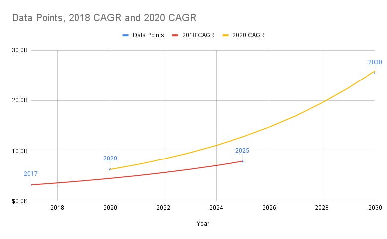
The two data points in the same report provide some conflicting views in terms of the growth of the GIS side of the market. Either the forecast from 2017 to 2025 was far outpaced, or there is a much more optimistic view of the future.
Yes, but. The geospatial market growth in the near future is clear, and GIS is only one small portion of that.

Why I switched my mail and calendar apps with Setapp
In the past two weeks, I have switched my email to Canary Mail and my calendar (and most tasks) to Structured. Both apps and 240+ others, are available in Setapp, a platform to access premium versions of all these applications.
Start your free 7-day trial (and support this newsletter) by clicking the button below.

The above are affiliate links. I only recommend things I use and I only share things that I would recommend to you in any other scenario. I may receive a small commission from a purchase at no extra cost, and you may receive an offer as listed above.
A new model for geospatial education is taking hold
Yale is launching a new Center for Geospatial Solutions. This past week Yale University announced a new interdisciplinary center for geospatial analytics, data, and data science. The center has stated goals including:
Focus and elevate the university’s support for geospatial research — particularly new, transformative place-based research — to address the most pressing challenges facing society and the planet
Strengthen the link from geospatial research to applications with societal and policy impact
Train the next generation of leaders in all fields with geospatial science skills
This center has some different attributes compared to a traditional geospatial or GIS education in that it exists as a stand-alone entity that looks to enable students in different fields with geospatial skills, rather than focusing on dedicated degrees for practicing GIS or spatial analytics.
This trend is growing in the United States. From my research, I found 37 such centers, institutes, or programs around the United States including the new center at Yale that have a similar interdisciplinary model. These centers are at universities of all sizes and are quite geographically distributed as well. The full list is:
Geospatial education as an integral skill in many areas. The main difference that I see between these centers and a more traditional GIS education is that in general, these centers view geospatial education as an additional and critical skillset to other core degrees and studies such as urban planning, climate science, sociology, engineering, intelligence, and more. This allows students in different fields to express their work through a geospatial perspective, without dedicating specific coursework or adding a second degree to learn those tools
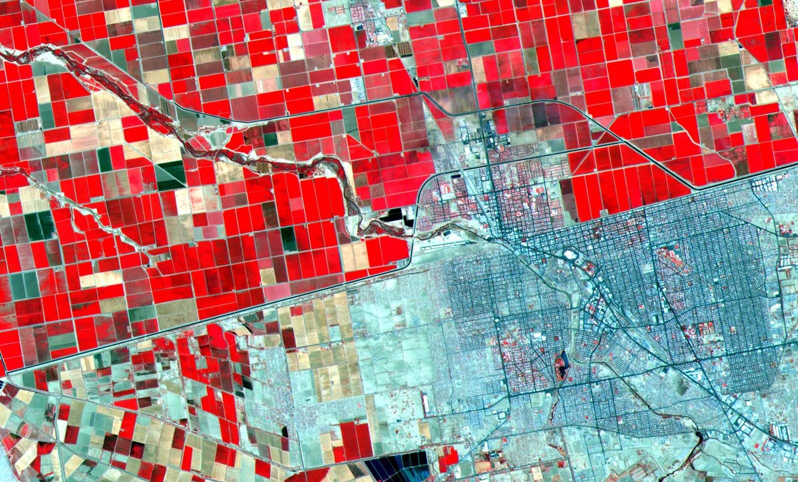
Is St. Louis the center of geospatial in the US?
The Taylor Geospatial Institute appoints Nadine Alameh as Inaugural Executive Director. The current CEO of the Open Geospatial Consortium, Dr. Nadine Alameh, Ph.D., was appointed as the Taylor Geospatial Institute’s first executive director this past week. Her experience and leadership roles are sure to be a major benefit to the Institute, which is only a year old.
The Taylor Institute takes a much larger vision of a geospatial institute. There are two factors that set the Taylor Institute apart from the other institutes listed above. First is that it is supported by eight different schools/institutions:
Donald Danforth Plant Science Center
Harris-Stowe State University
Missouri University of Science & Technology
Saint Louis University
University of Illinois at Urbana-Champaign
University of Missouri-Columbia
University of Missouri-St. Louis
Washington University in St. Louis
Second is that there is a stated vision and plans to make St. Louis the geospatial center of the United States and the world. Andrew C. Taylor, the namesake of the center states in this article:
“Geospatial is the critical technology in nearly everything we do, and it is imperative that St. Louis have the world’s leading geospatial research institution to fulfill our promise as the global center for geospatial technology in the next decade,” said Andrew C. Taylor, Executive Chairman of Enterprise Holdings, Inc. and Founding Chair of Greater St. Louis, Inc. “It is my hope that this institute will cement St. Louis as the world’s true center for geospatial excellence.”
In fact, Greater St. Louis, Inc., an organization focused on economic growth in the region, published a full report and roadmap on the future of geospatial in the region which can be found here.
There are a higher proportion of geospatial jobs in the region. Using a very unscientific and point-in-time method, I checked the number of jobs containing the term “geospatial” within 25 miles of St. Louis and other cities using LinkedIn. St. Louis has the third highest ratio of geospatial jobs to people in the cities I looked at, behind Seattle and D.C.

The top 5 cities in the cities I reviewed are:
DC: 1 to 2,275
Seattle: 1 to 3,756
St. Louis: 1 to 4,310
Denver: 1 to 4,463
Baltimore: 1 to 5,330
DC will almost always lead this pack due to the federal jobs in the region, but St. Louis is a leader given that it has the smallest metro population of the top 5 cities.
Thanks!
If you have something you want to share or a job you want to promote you can e-mail me here. Or if you want to sponsor a newsletter, video, or post, check out this link to get in touch.